 |
|
|
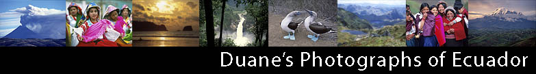
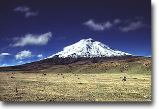
| Cotopaxi National Park is one of my favorite places to visit in all of Ecuador. Cotopaxi is one of the tallest active volcanos in the world. (Nevado Ojos de Salado between Chile and Argentina is the tallest) Cotopaxi is a nearly perfect shaped cone standing at 19,348 ft. or 5897m. As such, it's an easily identifiable landmark looking south from Quito on a clear day. Its volcanic activity, for the moment at least, is limited to the expulsion of steam and other gases. |
 |
 |
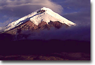
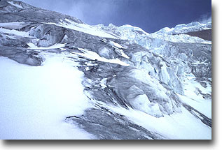
One of my favorite things to do is to to hike east from the refuge (located at 15,748 ft. or 4800m) towards the glacier. It is a truly beautiful sight to my eyes. As a photographer, Im always looking for a great shot. So I headed out on to the glacier as I had done several occasions before. |
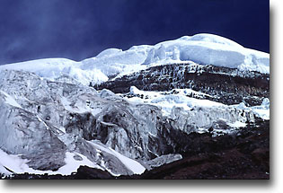
| I had decided to pursue a picture looking up the glacier from inside a crevasse. So I found one and entered to the point where I was standing about waist deep. Entering a crevasse, of course, is not exactly a bright thing to do. But I'm a photographer, not a rocket scientist. I had second thoughts about the idea and I decided Id better make sure I was standing on something solid before I went any further. So I hopped once, it seemed OK. To assure myself, I thought Id jump once more, just a bit harder. Apparently it was not all that solid since I quickly plunged downward into the crevass. Fortunately I was stopped by my shoulders and outstretched arms. My left knee wasnt so lucky, it received a rather nasty blow.I figured my guardian angel had saved me. But my knee hurt, so I decided to go back to solid ground. I had traveled back about 20 feet or so, when my right foot broke through the ice, plunging my entire right leg into a stream of ice cold water. Fortunately, my now out-stretched left leg kept me from being further submersed. But my left knee took another blow. |
 |
 |
I had traveled another 10 ft or so, when my left foot broke through the ice into another stream. Fortunately my right leg didnt break through. Unfortunately, my right knee received a rather nasty blow, making it more painful to walk. By this point, everything from the waist down was soaked with ice cold water and my hiking boots were full of water as well. The moral of the story... Well... I'd advise you to stay off the glacier, particulary at lower elevations where the daytime temperature is above freezing. As a matter of fact, climbers normally leave the refuge around 2 or 3 a.m. in order to reach the summit by dawn and return before the ice bridges become weak. |
| I have enjoyed camping at various spots around the base of Cotopaxi. It is very important to find a place that is out of the wind. Even though its on the equator, it gets really cold at night in the park. Youll definitely want a fire or a camping stove for warmth. Be forewarned there are no trees around the base of the mountain only rocks, mounds, ravines and a few varities of bushes and grass. So youll need to bring firewood from somewhere. |
 |
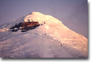 |
The park has a number of official marked camping sites. There is one area near the lake where camping is prohibited but usually permitted. I usually wait to pick my camping site until I get a good grasp of what the weather is going to be like at sunset. If its clear I usually camp towards the north-west side hoping for some colorful light on the mountain. If its cloudy, Ill camp on the east hoping the mountain will be clear for a little while at sunrise. |
|
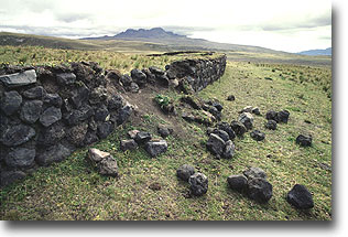
There is a small Incan fortress within the park, located in the valley on the northeast side of the mountain. It is somewhat similar to the incan ruins at Pomaski. The ruins are roughly a 2 hour hike from the intersection going up to the refuge. Stick to the road. Trailblazing a cross country path would not be easy as there are a number of ravines that would be difficult to traverse. There is one stream. The best place to cross on foot is the old broken log bridge next to the road. |
 |
 |
Cotopoxi National Park is home to a small number of animals and birds.
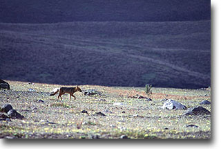
Ive personally seen deer and foxes. A more common sight are the wild horses usually seen grazing around the plain at the base of Cotopaxi. Of special interest to the birder is the endemic Andean Hillstar hummingbird. It can be seen flying to and from Chuquiragua bushes. The bushes are easily identifiable as they are the only ones with an orangish flower in the park. Other commonly sighted birds are the Andean lapwing and Andean gull. |
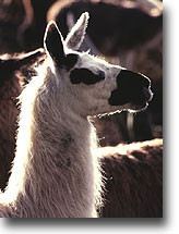
| Near the actual park entrance they have a small llama farm.
During the day the llamas are scattered throughout the woods,
but they are usually visible from the road.
Since it is a llama farm, the llamas have ear tags.
If you don't want ear tags showing in your images,
you will have a difficult time accomplishing it, but it is possible. In theory, the park is also home to the Andean condor, but Ive never seen one there. I hope you've enjoyed our brief photo tour of Cotopaxi National Park. I realize that I have left out a lot of the logistical info about getting to and from the park. This web page is certainly not meant to replace a good guide book. I own three that I like: Lonely Planet's Travel guide is the best for logistical purposes. Insight's Ecuador guide has a lot of great photos and is fun to read and look at. Rob Rachowiecki's Climbing and Hiking in Ecuador is a must for anyone considering doing either activity. All three have a few factual errors as any guide book will, but they are a great resource and a definite must if you are planning to visit Ecuador on your own. |
 |